A survey vessel will soon be beaming up an accurate picture of the seabed around Teignbridge’s coastline to give experts a better idea of what’s happening under the waves.
A survey vessel will soon be beaming up an accurate picture of the seabed around Teignbridge’s coastline to give experts a better idea of what’s happening under the waves.
Teignbridge District Council is lead authority for the South West Regional Coastal Monitoring Programme, part of a national project funded by the Environment Agency.
Managing the increasing risks of coastal flooding and erosion depends on officials obtaining consistent and reliable coastal data based on studying the undersea world around our shores. This gives them a deeper understanding of this shifting world to help them better predict future changes.
Teignbridge has commissioned Titan Environmental Surveys Ltd to accurately map the seabed between the Ness near Shaldon, across the frontages of Teignmouth, Holcombe, Dawlish, Dawlish Warren and through to Orcombe Point, which lies to the east of Exmouth.
Using the latest multi-beam scanning and positioning technology, the survey will give coastal managers an accurate picture of the depths and features of the underwater environment as well as the makeup of the sea bed – whether it’s sand and gravels, mud or rocks – and provide detailed analysis of any wrecks in the area.
Cllr Nina Jeffries, Teignbridge’s Portfolio Holder for Coastal Management, said: “This survey will give us a vital picture of what’s happening beneath the waves so we can understand sediment types and movements, and the effects these have on our much cherished beaches.
“It will also provide a scientific baseline to enable measurement of possible changes to the local environment following storm events. It will form part of the evidence needed to assess modelling and possible changes through developments, including those being proposed to enhance the resilience of the railway line”.
The survey is expected to start early in November and will include a small area of Brixham harbour on behalf of Torbay Council.
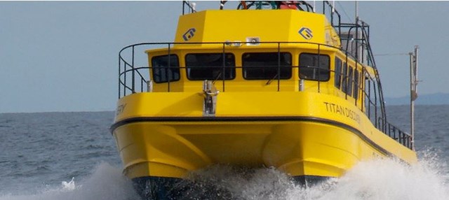
The survey vessel, Titan Discovery, will be in the area for several weeks and is easily identifiable, being a big bright yellow catamaran. Local yachtsmen and mariners are being asked to stay clear of the vessel whilst it’s working to enable the craft to work the best survey lines for the task.
The detailed bathymetric information will processed through the UK Hydrographic Office before being made public in the spring of 2020 for use by anyone with an interest in the management of our local coasts.

You can join us on our social media pages, follow us on Facebook or Twitter and keep up to date with whats going on in South Devon.
Got a news story, blog or press release that you’d like to share or want to advertise with us? Contact us


